MANILA, Philippines – The movement of ‘Bagyong Maring’ remains erratic over the Philippine Sea, state weather bureau PAGASA announced in its 5:00 am update on Friday, October 8, 2021.
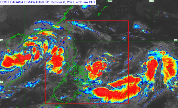
At 4:00 am today, the center of Tropical Depression ‘Maring’ was estimated based on all available data at 595 km East of Virac, Catanduanes or 540 km East of Catarman, Northern Samar.
 |
| Satellite image of ‘Bagyong Maring’ as of 4:30 am, October 8, 2021. Photo from PAGASA |
‘Bagyong Maring’ has maximum sustained winds of 45 km/h near the center, gustiness of up to 55 km/h, and central pressure of 1002 hPa. It is moving southward at 10 km/h. Strong winds or higher extend outwards up to 300 km from the center.
No Tropical Cyclone Wind Signal is currently in effect.
TRACK AND INTENSITY OUTLOOK
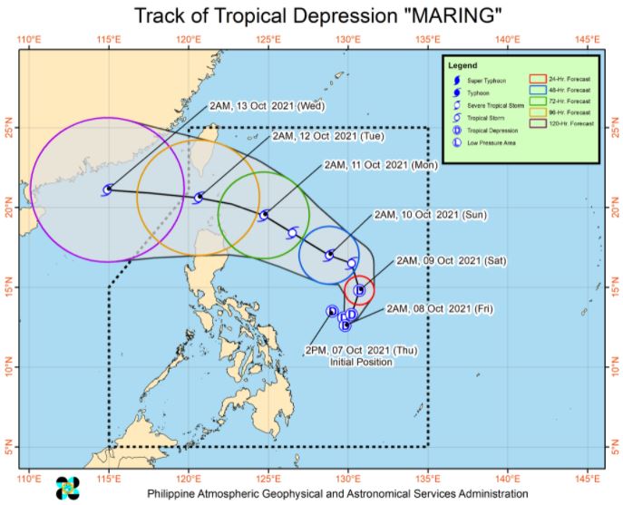
The tropical depression will continue moving erratically as it gradually consolidates over the next 12 to 24 hours. Afterwards, ‘Maring’ will move north northwestward on Saturday morning, then west northwestward on Saturday evening.
The cyclone is forecast to maintain a generally west northwestward heading until Monday. A more westward movement is likely by Tuesday as it moves away from the Luzon Strait.
On the forecast track, ‘Maring’ will likely track over the Luzon Strait and may pass over or near the Batanes-Babuyan Islands area between Monday afternoon and Tuesday early morning.
‘Maring’ is forecast to remain a tropical depression today through tomorrow early morning. Gradual intensification may take place beginning Saturday.
It may reach tropical storm category by the Saturday late morning. Current intensity forecast shows a peak intensity reaching 85 km/h within the forecast period.
Considering the trend of changes in the forecast scenario in previous bulletins, there is a moderate to high likelihood that changes may still occur in the track and intensity outlook for this tropical depression in the next bulletin.
HAZARDS AFFECTING LAND AREAS
Heavy Rainfall
Today, light to moderate with at times heavy rains are still possible over Eastern Visayas due to the trough of Tropical Depression ‘Maring’.
Light to moderate with at times heavy rains may begin affecting Occidental Mindoro, Palawan, and the rest of Visayas tomorrow as the southwesterlies enhanced by the depression begins to affect the central portion of the country.
Under these conditions, isolated scattered flooding (including flash floods) and rain-induced landslides are possible especially in areas that are highly or very highly susceptible to these hazard as identified in hazard maps.
Severe Winds
Current track and intensity forecast shows that there is a moderate to high likelihood that Tropical Cyclone Wind Signals (TCWS) will be hoisted over several provinces in Northern Luzon by early or mid-Saturday.
The highest possible wind signal for this tropical cyclone remains TCWS No. 2. However, due to the uncertainty in the track and intensity forecast, there is a possibility that areas outside Northern Luzon may also be placed under TCWS and that a higher wind signal may still be hoisted within the forecast period.
HAZARDS AFFECTING COASTAL WATERS
In the next 24 hours, moderate rough seas will prevail over the seaboards of Luzon and the eastern and western seaboards of Visayas and Mindanao.
These conditions are risky for those using small seacrafts. Mariners are advised to take precautionary measures when venturing out to sea and, if possible, avoid navigating in these conditions.
TROPICAL CYCLONES
‘Maring’, the 13th tropical cyclone for 2021, developed into a tropical depression while east of Bicol region on Thursday afternoon, October 7.
PAGASA predicts that 2–3 tropical cyclones may enter/develop in the Philippine Area of Responsibility (PAR) this month. On October 4, tropical depression ‘Lannie’ developed while east of Surigao del Norte and made 10 landfalls across northern Mindanao, the Visayas, and Palawan.
On average, there are 20 tropical cyclones that could form or enter the PAR each year. Only half of those are projected to make landfall.
The weather agency declared the onset of the rainy season on Friday, June 5.
— The Summit Express
‘Bagyong Maring’ PAGASA weather update October 8, 2021
Source: Trend Buzz Pinoy


0 Comments