MANILA, Philippines – ‘Bagyong Lannie’ is now over the Cuyo West Pass and moving towards the Calamian Islands, state weather bureau PAGASA announced in its 5:00 am update on Tuesday, October 5, 2021.
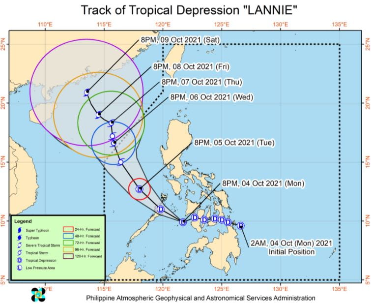
At 4:00 am today, the center of Tropical Depression ‘Lannie’ was estimated based on all available data at 90 km Northwest of Cuyo, Palawan or 70 km South Southeast of Coron, Palawan.
 |
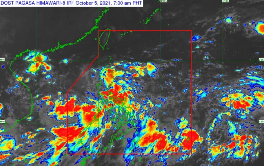
| Satellite image of ‘Bagyong Lannie’ as of 7:00 am, October 5, 2021. Photo from PAGASA |
‘Bagyong Lannie’ has maximum sustained winds of 45 km/h near the center, gustiness of up to 55 km/h, and central pressure of 1002 hPa. It is moving northwestward at 25 km/h. Strong winds or higher extend outwards up to 130 km from the center.
TCWS No. 1 (Strong winds prevailing or expected within 36 hours)
Luzon
- the southwestern portion of Romblon (Odiongan, Looc, Alcantara, Ferrol, Santa Fe, San Jose)
- the southern portion of Oriental Mindoro (Roxas, Mansalay, Bulalacao)
- the southern portion of Occidental Mindoro (Calintaan, Rizal, San Jose, Magsaysay)
- the northern portion of Palawan (El Nido, Taytay, Dumaran, Araceli) including Calamian and Cuyo Islands
Visayas
- Antique
- the western portion of Aklan (Madalag, Malinao, Ibajay, Nabas, Malay, Buruanga)
TRACK AND INTENSITY OUTLOOK
Tropical Depression ‘Lannie’ is forecast to make another landfall in the vicinity of northern mainland Palawan or Calamian Islands this morning before emerging over the West Philippine Sea shortly thereafter.
Over the West Philippine Sea, ‘Lannie’ will continue tracking northwestward and west northwestward until tomorrow morning while accelerating.
On the forecast track, it will likely exit the Philippine Area of Responsibility (PAR) tomorrow afternoon or evening.
Outside the PAR region, it is forecast to turn north northwestward and move towards southern mainland China or Hainan Island.
The weather disturbance will likely remain a tropical depression today. Slight improvement in environmental conditions will allow it to intensify into a tropical storm tomorrow morning as it nears the border of the PAR. Further intensification is possible as the cyclone moves towards southern China.
HAZARDS AFFECTING LAND AREAS
Heavy Rainfall
Today, moderate to heavy rains are likely over Palawan including Calamian and Cuyo Islands. Light to moderate with at times heavy rains are also possible over Metro Manila, Western Visayas, Bicol Region, CALABARZON, Central Luzon, and the rest of MIMAROPA.
Under these conditions, isolated to scattered flooding (including flash floods) and rain-induced landslides are likely especially in areas that are highly or very highly susceptible to these hazard as identified in hazard maps.
Severe Winds
Strong winds (i.e., strong breeze to near gale conditions) with occasional gusts will be experienced within any of the areas where TCWS No. 1 is in effect during the passage of the tropical depression.
This may generally cause up to very light damage to structures and vegetation.
An enhanced easterly flow north and southwesterly flow south of the tropical depression may also bring occasionally gusts reaching near gale to at times gale-force in strength over Extreme Northern Luzon and the coastal and upland/mountainous areas of Cordillera Administrative Region, mainland Cagayan Valley, Ilocos Norte, Central Luzon, CALABARZON, MIMAROPA, Bicol Region, Western Visayas, Zamboanga Peninsula, and Bangsamoro in the next 24 hours.
HAZARDS AFFECTING COASTAL WATERS
In the next 24 hours, ‘Lannie’ will bring moderate to rough seas over the coastal waters of the country, especially in areas where TCWS No. 1 is in effect and over the seaboards of Northern Luzon.
These conditions are risky for those using small seacrafts. Mariners are advised to take precautionary measures when venturing out to sea and, if possible, avoid navigating in these conditions.
TROPICAL CYCLONES
‘Lannie’, the 12th tropical cyclone for 2021, developed into a tropical depression while east of Surigao del Norte early Monday, October 4.
PAGASA predicts that 2–3 tropical cyclones may enter/develop in the PAR this month.
On average, there are 20 tropical cyclones that could form or enter the PAR each year. Only half of those are projected to make landfall.
The weather agency declared the onset of the rainy season on Friday, June 5.
— The Summit Express
‘Bagyong Lannie’ PAGASA weather update October 5, 2021
Source: Trend Buzz Pinoy


0 Comments